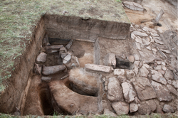
The Mongolian Arc is a 405-kilometer-long segment of a broader frontier system that extends more than 1,500 kilometers across present-day Mongolia and northern China. Situated in Dornod and Sukhbaatar provinces, the Arc runs through a hilly-steppe region parallel to the modern border between China and Mongolia. We surveyed this section in 2022 following satellite imagery analysis and remote sensing documentation. During the field survey, 34 rectangular enclosures were identified along the wall line, most of them directly associated with the Mongolian Arc. Excavations were conducted in 2023 at two sites, MA03 and MA20. Radiocarbon dating from MA03 places the construction of the Mongolian Arc in the early to
mid-period of the Jurchen (Jin) dynasty (1115–1234). The enclosure walls and internal structures were built with rammed earth and stone, while the wall itself appears as a shallow trench rather than a formal rampart. These findings shed new light on the construction techniques, functions, and historical role of the Mongolian Arc. In contrast, Site MA20 appears to represent a later structure, unrelated to the broader Jin frontier system.