


The Northern Line
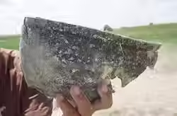
The Northern Line extends for 737 kilometers across what are today parts of northeastern China, southern Siberia, and Mongolia. In Mongolia, it traverses sparsely populated and largely undisturbed steppe. Unlike other defensive systems, this line is not connected to adjacent wall networks. Instead, it runs between two mountain ranges—the Da Xingan Range in the east and the Khentii Mountains in the west—effectively sealing off the wide lowland corridor between them. Our remote-sensing and ground surveys identified 72 individual structures along the course of the line, grouped into 42 clusters, each containing between one and three structures. In 2018, we conducted vehicle-based and pedestrian surveys along the Mongolian segments of the line. Subsequent campaigns in 2019, 2021, 2022, and 2024 included targeted surveys, geophysical investigations, and excavations at three of these clusters. Radiocarbon (C¹⁴) samples from the sites date the construction and use of the Northern Line to between the 11th and early 12th centuries CE, suggesting that it was built under the Kitan (Liao) dynasty (916–1125). One particularly striking discovery is that, while the structures (enclosures or camps) are surrounded by massive rammed-earth walls and deep ditches, the “wall” line itself consists only of a ditch—approximately 2 meters deep and 4 meters wide—with no corresponding wall built on its inner (southern) side.

Excavations at Cluster 23
This sectio presents the excavation areas in Cluster 23, which consists of two square elements and one circular feature.
You can zoom in and out on the map to explore the different excavation areas. Photographs from each area update dynamically as you navigate.
Use the buttons below to move to Cluster 24 or return to the main survey map.


Excavations at Cluster 24
This section presents the excavation areas in Cluster 24, which consists of one square elements and one circular feature.
You can zoom in and out on the map to explore the different excavation areas. Photographs from each area update dynamically as you navigate.
Use the buttons below to move to Cluster 24 or return to the main survey map.

Excavations at Cluster 27

 Lorem Ipsum |  Lorem Ipsum |  Lorem Ipsum |
|---|---|---|
 Lorem Ipsum |  Lorem Ipsum |  Lorem Ipsum |